Sunday, 10 February 2013
Uttarakhand Pithoragarh Hill Station
Pithoragarh Weather, India
 | Sun, 10 Feb Max: 22°C (71°F) Min: 8°C (46°F) 8mph / 13kph (NW) |
Pithoragarh is a city having a Municipal Board in thedistrict of Pithoragarh in the Uttarakhand state. In the year 1960, it was carved out of Almora district.
Geography
Pithoragarh is having a mean elevation of 1,514 m.
Overview
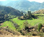
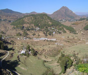
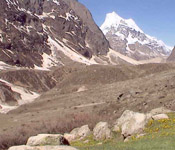
Pithoragarh remains a beautiful and small town having the same name of its district. It falls at the centre of western Soar valley that resembles to the Kashmir valley to some extent. It is beautifully marked with villages, basically placed on respective eminences. There are beautiful views from the higher altitudes of Pithoragarh which are snow-bounded peaks of Nanda devi, Panch Chulhi and Nanda Kot.
The town is found in a valley well known by the name "Soar" which means cool and falls at the centre of 4 hills Dhwaj, Chandak, Thal Kedar and Kumdar. It stretches in the southern direction to Jhulaghat and is distinguished by the Kali river which further adjoins the Nepal hills peaks.
Pithoragarh, is also considered as the gateway to the Himalayas in the northern direction as the pilgrims do trekking through the town to Om Parvat, Kailash and Lake Mansarovar.
Pithoragarh, is also considered as the gateway to the Himalayas in the northern direction as the pilgrims do trekking through the town to Om Parvat, Kailash and Lake Mansarovar.
History
After the rule of the Uku Bhartpal Rajwar in 1364, Pithoragarh as a whole was under the rule of 3 generations of Pals by the 14th century. The kingdom remained expanded from Pithoragarh to Askot. People believe that Bhartichand’s ancestor, Gyan Chand, replaced the Pals, the king of Pithoragarh, when he defeated them in the year 1445. The Chand dynasty in 16th century took over the town of Pithoragarh and in 1790, constructed a new fort, on the hills where at present there is a Girls Inter College located.
The current ruler of the Kumaon is Mahendra Chand belonging to Lamakhet i.e. Pithoragarh, he got married to Gita Chand belonging to Rina and the couple has three children Aryan Chand, Aakanksha Chand and Mallika Chand.
The name of the district is after Pithoragarh, the headquarters town.As per the traditions, the rule of the Chand Rajas belonging to Kumaon, there is one Piru, also known as Prithvi Gosain, constructed a fort here and called it Prithvigarh which further got transferred into Pithoragarh.
Video
Places of Interest
This town consisted of two forts, one of which had been demolished, and at its place there is a Girls Intermediate College of Government. The other fort is a home to treasury as well as a tahsil.
The places of interest in Pithoragarh being Patal Bhuvaneshwar, Dewalthal, Chandak, Munsiyari, Dharchula and Kali Mandir in Gangolihat, there is also a Kumaon University College which is the major educational institution of the district.
Chandag- at a distance of 5 km. from here is a beautiful and small place called Chandag which is the house or an asylum meant for lepers. People believe that there was a goddess who killed 2 devils, Mund and Chand here. This incident gave this place the name, Chandghat.
Pithoragarh Fort
It is found on top of the hill at the outskirts of this town. This fort in 1789 was constructed by the Gorkhas.
Kapileshwar Mahadev: There is a cave temple in dedication of Lord Shiva which offers the view of Soar valley as well as the lofty peaks of Himalayas.
Kapileshwar Mahadev: There is a cave temple in dedication of Lord Shiva which offers the view of Soar valley as well as the lofty peaks of Himalayas.
Maharajke Park
The park was constructed by the Indian Military memorizing the warriors who gave their lives in Kashmir and offers a beautiful view of surroundings, basically small peaks covered with bushes and grass.
Kamakhya Devi Temple
There is one more amazing site, the Kamakhya Devi temple, located at the small hills top close to the town. It provides the majestic view of the scenic surrounding valley.
Map
Photo Gallery
 |  |  |
Subscribe to:
Post Comments
(Atom)
0 comments:
Post a Comment