Thursday, 31 January 2013
Ujjani Dam
There is a project that started on the Bhima River and the name of that project was Ujjaini Dam. The alternate name of this dam is Bhima dam. It is also known as Bhima Irrigation Project. Through this name, large number of people knows it in the area where the dam is located. This dam is constructed on the subsidiary of Krishna River and it is located in the area of Ujjaini Village which is located in the Solapur district. It comes under the Madha taluk of that state of Maharashtra. The river of Bhima originates from the Bhimshankar which is in Bhimshankar Ghats. Then it forms a valley of Bhima Valley and it also forms its tributaries. On its tributaries and including the main river, there are 22 dams built and along all of them, Ujjaini Dam is the main primary dam. It is the largest dam in the valley with having a total area of 14858 kilometres square. The construction was started in the year of 1969 of this dam including the other canals which are associated with it. These canals are located at both banks and the total cost of constructing all these things include Rs.400 million and it got completed inthe year 1980. The total cost which the construction period took was Rs.3295.85 million.
There is a earth cum gravity concrete dam is created on the River Bhima through which people are getting support in large number of ways. This reservoir is having annual utilization of large number of water which is mainly for irrigation to the land which is ready for agricultural purpose. Also it provides help to the district of Solapur in getting the drinking water, water for hydroelectric projects, water for fishes and also for various industries which are established in that area as well.The water which is stored in the reservoir is very helpful for the people during the situations like drought that happens in large number in this area. Through this reservoir, people also get restrictions among threats of floods and it also serves for the same purpose to the village of Paqndharpur.
Photo Gallery
 |  |  |
Geography
Bhima River originates from the Bhimshankar Hills which are located in the Western Ghats. It is the river on which the dam was constructed. This hill is also known as Sahyadri Hills. Before meeting to the Krishna River, it flows around 725 kilometres in length. It meets in the districtof Narsingpur which comes under the city of Solapur. There are various tributaries of Bhima River Basin. They include Kumandala River, Ghod River, Mutha River, Kundali River, Mula River, Indravani River and many more. The total drainage of this river is 48631 kilometre square. Bhima River Basin is also known as interstate basin which is serving both states of Maharashtra and Karnataka with 75 and 25 percent respectively. Large amount of water gets reserved under the Ujjaini Reservoir which is created under the same dam. There are three zones in which the whole Bhima River Basin is divided and these three zones are southern, middle and northern. The main stream is the middle zone which is having the Ujjaini Dam itself that is serving to the people. The southern zone is having 5 reservoirs into which it is dominated. The reservoir is helping the people with large number of things for which water may be used. Through this way, it is effective for irrigation, industrial and for domestic purpose. There is a slope which is from west to east with this basin and it is having variations of agro climatic and physiographic. The drainage basin is serving the people with irrigation through providing water for their fertile land. Apart from this, large numbers of development projects on water resources are also running on this basin. There are different stretches are classified by the Government of Mahrashtra over the various purposes of water that is under the Bhima River. In this context, A-1 is for drinking purposes, A-2 is for drinking water but they are full of impurities that may lead to disinfection, A-3 is for fishes and other wildlife.The last and A-4 is for industrial purposes. The best way to come to this dam and its reservoir is from Pune city which is located near to it. A person may take few hours to reach to this place.
Climate
The climate that revolves around the basin is tropical monsoon climate. Rainfall occurs in the place but through southwest monsoon. The rainfall happens for just 3000 to 6000 mm. it happens in the mountains for 700mm. most of the rains happens in other parts of the valley. The basin got good support from this weather as it gets large amount of water into its reservoir. Almost 47 percent of the water is trapped in the reservoir which is a good thing for it. Since it has to serve water for various purposes, it is very effective through monsoon weather. Most of the rains occur in the months of June and it continues to the mid of September. The rain is very effective that happens in this time as it provides good water that is supportable during the conditions of drought that occurs in the area. Sometimes, it rains when the monsoon is moving towards east and at that time, the reservoir gets around 600mm.
Hydrology
As per the data available from rainfall and depend upon the other things, the annual water conservation from the Bhima River Basin is 7313 kilometre square. Since the river flows to the Krishna River and also having some other subsidiaries of it and also it serves to two states, Maharastra and Karnataka, it provides water through upper riparian to Maharashtra and through lower riparian to Karnataka. Maharashtra is entitled to use only 4753 kilometre square of water from the upper basin of Bhima River. This permission is given to them through the Krishna Water Disputes Tribunal as an award in the year 1976. the annual utilisation was planned for conservation is 1878 kilometre square.
Features
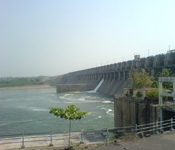
The inauguration of Ujjaini Dam was done in the year of 1980. It is constructed throughconcrete and earth mason. It is also having a multipurpose reservoir through which person use water for various purposes like for domestic use, irrigational facilities and also for industrial purposes. The dam is largest dam of the area and it is also having its own canals through which it is possible to deliver water for different use for the people in area. The length of this dam is 2534 metres and it is having a spillway dam which is the central portion which is of 602 metres. The right content which is inside the tank is of 3320 kilometres square. There are various other sections also divided in the dam. There are 4 rivers which are added to this dam. They are located at the gate of it. They are located at the body of spillway and they are at gate numbers 3, 4, 5, and 6. The outlet level of it is 470 metres. Measuring instruments are also installed inside the reservoir so that one may record and analyse the water level at various parameters and also in relation of the behaviour of dam from a long years. This all is done for the safety of the dam.This dam is created on the rock formations of massive basaltic. The energy dissipation at the downstream are arranged in the low level and high level format through a slotted roller which is of bucket type. The gross capacity of this reservoir is 3320.00 kilometres cubic.It is having two sections. The first section is of non Overflow and the other one is of Full Reservoir Level.The spillway section is in the shape of Ogee and it is a downstream slop. It is design to dispose the water of flood.
Reservoir
The total water which is present under the dam is of 357 kilometres square. It is at the High Flood level. It is also having 336.5 kilometres square which remains at Full Reservoir Level. It causes submergence of houses and all lands which is there in 82 villages. The upstream of the water is having a length of 134 kilometres and width of reservoir is 8 kilometre over all. Due to the submergence of reservoir, it also affected the railway route of Dhound Solapur division. It also shifted the national highway number 9 of Solapur and Pune to 23.4 kilometres and state highway between Karmala and Tembhurni to 15.35 kilometres.
After commissioning the project for two year, the quality of water was tested, which was their in the reservoir, It was checked to certify it for the various uses that it may provide. The analysts checked the water on all the quality levels and also on the pH values. They also checked the availability of sodium, nitrate, carbon dioxide, oxygen and other metals in the water. Through all these means they proved that the quality of water is sufficient for all the purposes. Heavy metals and other particles are also not presented in that water. During the rainy season, iron content was available in the water but still it was under the permissible limit. The limit of potassium and ammonia potassium were also in the acceptance in the stored water which is used for industrial, fisheries and also for domestic purposes. After the creation of this dam in 1980, it was discovered that there was untreated sewage deposited into the streams which flows to the dam’s reservoir. It also flows to a river that flows very close to the Pune city and people also use water from this reservoir.
The reservoir which is available inside the dam is the largest wetland in the Asia. Its name is Bhadalwadi Lake. Large number of migratory birds attract to this place form the time of its construction in the year of 1980 because of the backwaters that the reservoir is holding with it. As per the calculations, near about 100 to 150 species land to this place and enjoys the water which is present in this reservoir. These birds also include flamingos in large amount. The Science and Technology Park which is located in Ujjaini is researching on the birds which are migrating to this place. It is a Pune based institution which woks under the Ministry of environment and Forests. Through this means, the reservoir is known from the name of Wetland of International Importance. It is also having a Ramsar convention which is having 384 aquatic animals present over this place. Among the, 112 species are of birds. There are different other categories of animals and species also resides.
Benefits
The dam is having large amount of water which is stored in the reservoir because of which a person may use it for different other purposes apart from drinking. A person may use the water for irrigating the agricultural land and he may use it fort industrial sake as well. Large amount of water is transferred to the city of Solapur where the consumption is at higher level. Most of the people also do fisheries through this water only and it is possible for them to use the water.
Irrigation
There are two irrigational canals which are originated from this dam through which irrigation process is possible through the reservoir. These two canals are Right Bank Main Canal, which is 112 kilometres in range and may discharge water for 44100 cubic metres per square. The other one is Left Bank Main Canal which is 126 kilometres in range and may discharge water for 688.4 kilometres square. Through these two irrigational plants, it is possible for that land in large number to irrigate plants of different types which are helpful in fulfilling the demands of the people. These two are the effective canals which are helping the farmers a lot.
The main benefit of the storage which is created inside the Ujjani Dam is taken by Solapur district itself as a long area of 500 kilometres square gets the facility of irrigation. This improves the quality and quantity of Jowar and Groundnut which rises to double and triple in ratio respectively. The management which is organised by the farmers provide full support to the irrigation system and it moves in a command the financer of this irrigation system is ICFAD and World Bank through which all the things are possible. It is done to facilitate the scheduled caste and scheduled tribes who are living in these region.
Hydropower
With a capacity of 12 Mega Watt, a storage powerhouse with pump is installed at the toe of the dam. It is one of the units of Vertical Francis reversible pump turbine. It is locate at the left bank of the dam and it is metre long which is flowing towards down from the axis. It is having a load factor of 20 percent and it is having maximum range of 36.77 metre and minimum range of 25.6 metre. This hydropower component is also having a constructed weir which is 13.42 metre. It is designed to control the lower pond which is located below to the Ujjani Dam. This is done to protect the pumping mode while operation is in process.A penstock pipe is also installed inside the dam through which flow may be diverted through a gate which is controlled through racks which are covered through intake of powerhouse. This lower pond was constructed as soon as the commissioning of this dam. From that particular time, power plant started providing benefits to the people. The generation of water reduced to some extent and this is possible through the canals which are located at both left and right side of the dam.
Other Benefits
There are various species located at the Ujjani Dam of and among them; there are large number of fishes available to this place.The production of fishes through this reservoir is getting more than estimation of 712 tonnes a year. Among this there are species of major carps are also included which is of 19 percent. There is an estimation of 2450 kilograms per kilometre is yielded from the reservoir every year.
Attractions
There is a place called Pandharpur which is located at the distance of 65 kilometres from the main district of Solapur and it is also located at the banks of river Bhimarathi. It is also known as the better pilgrimage centre of the state of Maharastra. It is having various names like Vitthal, Pandhari or Pandurang. The meaning of this name is the supreme go of all the people of Maharastra and it is also known as Lord Vishnu through the name of Vitthal which is a Kannada term. The older Sanskrit name of Panduranga is Pandarga. The last name of Pundalik is a name of a saint which was very close to this place. This place is also known as Pundarika Pura. Pandharpur is also known as Pandarpur. It is one of the biggest devotion places of the state and large numbers of people use to come to this place. The most important and attractive thing about this place is that it is also related to traditional and ancient India. Because of all these things, it is also known as the religious capital of Maharastra. This is the place which is dedicated to beloved God who came down to the earth to greet his people and devotees.
At the place of Pandharpur, every Wednesday is celebrated as the propitious day and every Ekadashi, means Eleventh day of the month is also celebrated as the fortunate day. The place of Pandharpur also hosts Yatras which held four times in a month. Large number of pilgrims use to come to this place every year as four best days in a year naming Eakadashi, Kartiki,Chaitra and Magh including the Aashadhi Yatra is also celebrated over this place. It also facilitates the tourism of this place as well. There are large number of people come to this place to celebrate the festival of Magh and Kartiki. As per the estimation, 8 to 10 lakh people use to come to these festivals. It also welcomes large number of saints from all the cities. Most of the people use to come to this place and also take a holy dip in Bhima River.They also stand in a queue which is of 3 kilometres to take a darshan of Lord Vitthala.
The temple is also having 6 vast gates among which eastern entrance is also known as the Namdev Gate. A chamber of the temple is having a standing image of Lord Vitthala or Panduranga.
The very important thing about this place is that the district of Solapur enjoyed the independence prior to the independence of the country as well. This is the reason because of which large number of tourists uses to come to this place.
Subscribe to:
Post Comments
(Atom)
0 comments:
Post a Comment